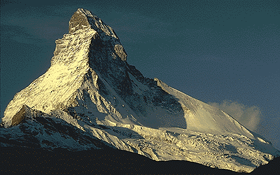
River deep, mountain high... -Tina Turner
In this lecture period, we learn:
09/28/2007 The Shape and Size of Earth A
good way to look at a planet is by taking a globe in your hands. Because 3-dimensional objects are not convenient
to carry around, early on in our traveling history the art of map making
was invented. Maps of the earth offer 2-dimensional representation of a
3-dimensional object. Because Earth is a sphere, different projections
were developed to emphasize different aspects. Perhaps you recall the experience
that the shortest distance between points on a map was connected by a curved
trajectory. For example, the connections in airline magazines illustrate
this property nicely. Another important aspect is the area distortion of
many maps. Whereas Alaska is a large state, it appears yet even larger
because the E-W distances are commonly the same on maps, but not on a sphere.
Such E-W lines are called latitudes, whereas N-S lines are called longitudes.
Note that longitudes are all of equal length (circumference of the Earth),
but that latitudinal lines are of different length. The longest latitude
is the equator, which equals the circumference. A
good way to look at a planet is by taking a globe in your hands. Because 3-dimensional objects are not convenient
to carry around, early on in our traveling history the art of map making
was invented. Maps of the earth offer 2-dimensional representation of a
3-dimensional object. Because Earth is a sphere, different projections
were developed to emphasize different aspects. Perhaps you recall the experience
that the shortest distance between points on a map was connected by a curved
trajectory. For example, the connections in airline magazines illustrate
this property nicely. Another important aspect is the area distortion of
many maps. Whereas Alaska is a large state, it appears yet even larger
because the E-W distances are commonly the same on maps, but not on a sphere.
Such E-W lines are called latitudes, whereas N-S lines are called longitudes.
Note that longitudes are all of equal length (circumference of the Earth),
but that latitudinal lines are of different length. The longest latitude
is the equator, which equals the circumference.
Already in the 3rd Century BC, a Greek librarian named Erathosthenes accurately defined Earth's circumference. The method is very creative. When the sun stands vertical at one point, measured by shining down the bottom of a well, it casts a shadow elsewhere. At a distance of 800 km, Erastosthenes measured an angle of 7.2 degrees from vertical between the top of a wall and the tip of its shadow. Thus an angle of 7.2 degrees describes an arc of 800 km on the Earth's surface. In a full circumference of 360 degrees, this would describe an arc of 360/7.2 x 800 = 40,000 km. Erasthothenes' calculation is within tens of kilometers of today's determination. Topography
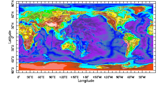
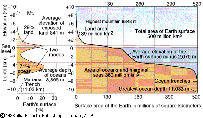
Rather than looking at coastlines only, we examine the elevation (or topography) of the Earth.
We create a graph showing
the total surface area at a certain elevation, which is called a hypsometric
curve. The figure shows both a hypsometric curve (or cumulative frequency
curve) and the more familiar histogram.
Raise sea level by 200m (through melting of continental ice sheets) and see what our continents will look like from today's coastlines (move mouse over image). You can further experiment with sea levels and topography, and look at details for your favorite area by going to the LDEO site.
Two rocks: Granite and GabbroWe can generalize the composition of the continents and the ocean floor by two igneous rock types: granite and gabbro (or their extrusive equivalents, rhyolite and basalt). Granite is a rock a light-colored consisting mainly of the minerals quartz and feldspar, with various minor phases (such as mica, hornblende). Chemically, granite are high in Si (~70%) and Na, K; it has relatively low Ca and Mg content. Gabbro is a dark-colored rock consisiting mainly of the minerals feldspar, olivine and pyroxene. Chemically, it has low Si, Na and K content, and relatively high Ca and Mg content. These compositions are responsible for a difference in density for these two rock types: granite has a density of ~2800 kg.m-3, whereas gabbro is slightly more dense (~2900 kg.m-3).Isostasy
The density difference between granite and gabbro has an important consequence that we can illustrate by simple experiment. If we float a piece of hardwood (like oak) and and a piece of softwood (say, pine) of equal dimensions in a bucket of water, we see that the hardwood rides lower than the pine. The reason is that hardwood has a slightly higher density than softwood, and thus is heavier. Secondly, we float a a piece of wood that is twice as thick as the original piece. The thicker piece sinks deeper and rides higher. Since the weight of a body equals the weight of the liquid is displaces (Archimedes' Principle), thicker or denser blocks will displace more water. We can apply this experiment to the Earth, with the granite and gabbro as our wood blocks and the deeper mantle as the water.
Thickness is important, illustrated by icebergs. Ice floats in sea water because it has a lower density (rhoice=920 kg.m-3, rhoseawater=1025 kg.m-3). Using Newton's Second Law, F = m * g (recall that with m = volume x density) and Archimedes principle, we get: volice . rhoice . g = voldisplaced water . rhowater . g. So, rhoice/rhowater=voldisplaced water/volice. Thus the ratio of displaced water/ice volume equals 0.9 meaning that 90% of an iceberg is below sealevel, whereas only 10% is above sea level. Thus, density and thickness contrast between granite and gabbro (continent vs. ocean floor) both promote relatively high continents and relatively low ocean floor. Density, therefore, is a first order property that explains Earth's characteristic bimodal elevation distribution. Layered Earth
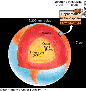
How do we know that there is radial variation in Earth? There are several ways this can be surmised, but one good indicator is average density of Earth. Rocks at the Earth's surface have a density around 3000 kg.m-3, whereas the average density of Earth exceeds 5000 kg.m-3. Let's figure out how we know this and along the way determine a few other properties of our planet.
Copyright and Use Statement: Regents
of the University of Michigan
|